Kentish trails masterplan released
Progress continues on the Latrobe-Kentish Mountain Bike Trail Network with the release of TRC Tourism's draft Kentish Mountain Bike Trails Masterplan report. I'm still trawling through the report myself, but it is attached below for those who want to have a look.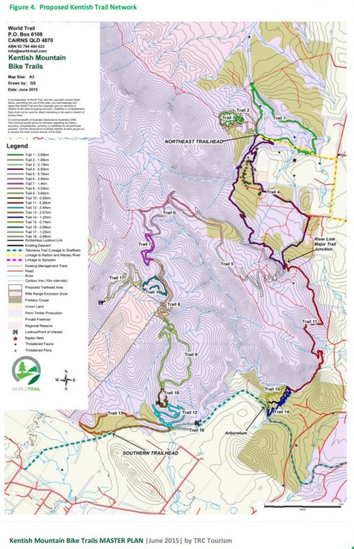 Here's more information from the facebook page, posted 8 July, 2015:
----
G'day all good to see things are happening and still moving forward. Check out the PDF of the Kentish Mountain Bike Trails MASTER PLAN on this page. Adding to this, some added info from Chris Frankcombe below.
1. Clarification on trail head location.
The Master Plan identifies two Trail Heads – the “North-East’’ trailhead near Railton and the “Southern’’ trailhead near Sheffield.
The Sheffield trailhead will be moved 300m west of the location marked on the map, to the Sheffield Recreation Ground. This will therefore involved a 300m flat ride from the conclusion of the trails to the car park. This is because cracking trailhead facilities already exist at the ground – toilets, changeroom, showers, running water, power, already exist there, and additional facilities such as car park, camp ground, event hosting, shelters etc are easier built there.
The northeast trail head will be in the location marked on the map, for purposes of events. However, it is proposed the public will actually start their ride 3km west, at Goliath Park in Railton. Again, all the existing facilities for riders exist at Goliath park. It will be connected by a 6km single-direction loop trail from Goliath Park to the start of the tracks, at the point marked as “North-East trail head’’.
2. Cross-country linking trails:
The cross-country transition trails, which connect this Kentish trail system to a sister trail system at Warrawee at Latrobe, and to Devonport, are not included in this report. They will be the focus of a separate report. Work has been done by Chris Stredwick and his team on routes to be explored, across the Badgers ridgeline, to connect the Kentish trails to Devonport via Coal Hill Rd at Latrobe, and River Rd through Ambleside to east Devonport. Secondly, two trail routes are being explored to link Latrobe to the trail cluster at Goliath Park, Railton. The two proposed routes are to follow the existing Tasmania Trail from Latrobe to Railton(the Tasmania Trail presently follows some country roads – the road sections would be replaced by a multi-use trail along the road reserve of these roads), Option 2 is to erect a flying fox or suspension bridge across Mersey River at Warrawee, and create new trail through Forestry Tasmania managed land from Henry Somerset Orchid Reserve to Railton. Both options are presently being explored for experience quality and cost. We hope to have an answer in August.
3. Warrawee Master Plan:
The receipt of this draft report sparks the start of the Warrawee trail cluster Master Plan development. Subject to Latrobe Council approval, it is envisaged local mountain bike enthusiasts might design this trail cluster, led by Chris Stredwick and his team. It would comprise about 12km of trails, including some specialty features such as a pocket park, perhaps a jumps track, and maybe a gravity track (subject to what your club members propose). We would love to have your involvement in this project. It is proposed to complete a draft Warrawee Mountain Bike Master Plan by October.
Here's more information from the facebook page, posted 8 July, 2015:----
G'day all good to see things are happening and still moving forward. Check out the PDF of the Kentish Mountain Bike Trails MASTER PLAN on this page. Adding to this, some added info from Chris Frankcombe below.
1. Clarification on trail head location.
The Master Plan identifies two Trail Heads – the “North-East’’ trailhead near Railton and the “Southern’’ trailhead near Sheffield.
The Sheffield trailhead will be moved 300m west of the location marked on the map, to the Sheffield Recreation Ground. This will therefore involved a 300m flat ride from the conclusion of the trails to the car park. This is because cracking trailhead facilities already exist at the ground – toilets, changeroom, showers, running water, power, already exist there, and additional facilities such as car park, camp ground, event hosting, shelters etc are easier built there.
The northeast trail head will be in the location marked on the map, for purposes of events. However, it is proposed the public will actually start their ride 3km west, at Goliath Park in Railton. Again, all the existing facilities for riders exist at Goliath park. It will be connected by a 6km single-direction loop trail from Goliath Park to the start of the tracks, at the point marked as “North-East trail head’’.
2. Cross-country linking trails:
The cross-country transition trails, which connect this Kentish trail system to a sister trail system at Warrawee at Latrobe, and to Devonport, are not included in this report. They will be the focus of a separate report. Work has been done by Chris Stredwick and his team on routes to be explored, across the Badgers ridgeline, to connect the Kentish trails to Devonport via Coal Hill Rd at Latrobe, and River Rd through Ambleside to east Devonport. Secondly, two trail routes are being explored to link Latrobe to the trail cluster at Goliath Park, Railton. The two proposed routes are to follow the existing Tasmania Trail from Latrobe to Railton(the Tasmania Trail presently follows some country roads – the road sections would be replaced by a multi-use trail along the road reserve of these roads), Option 2 is to erect a flying fox or suspension bridge across Mersey River at Warrawee, and create new trail through Forestry Tasmania managed land from Henry Somerset Orchid Reserve to Railton. Both options are presently being explored for experience quality and cost. We hope to have an answer in August.
3. Warrawee Master Plan:
The receipt of this draft report sparks the start of the Warrawee trail cluster Master Plan development. Subject to Latrobe Council approval, it is envisaged local mountain bike enthusiasts might design this trail cluster, led by Chris Stredwick and his team. It would comprise about 12km of trails, including some specialty features such as a pocket park, perhaps a jumps track, and maybe a gravity track (subject to what your club members propose). We would love to have your involvement in this project. It is proposed to complete a draft Warrawee Mountain Bike Master Plan by October.
Stay Informed
When you subscribe to the blog, we will send you an e-mail when there are new updates on the site so you wouldn't miss them.
About the author
Comments
No comments made yet. Be the first to submit a comment