- Road Rides
- Launceston Airport Cycling Route
Launceston Airport Cycling Route
Hot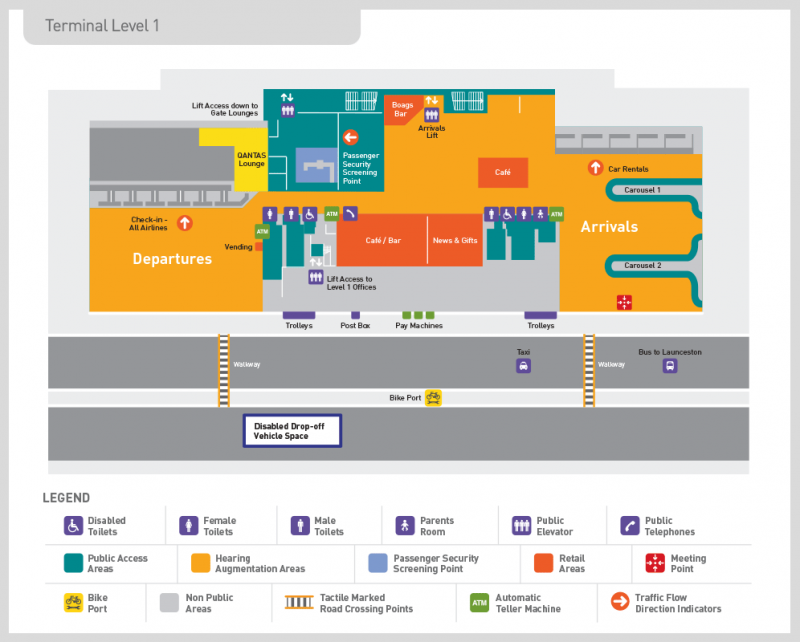
Key Statistics
- Not specified
Overview
It is about a 15km ride from Launceston Airport into the centre of Launceston, and there isn't a brilliant way to ride into Launceston from the Airport. The route described below does however keep you off the main highway and follows frequently roads ridden by local riders. The good news is that it is a largely flat to downhill ride into Launceston.
At the Airport
Launceston has undercover bicycle facilities located within the short term car park, immediately opposite the terminal forecourt and approximately 65m from the terminal entrance/exit doors (see airport plan in the photos). This facility includes two bicycle service stations with accompanying cycle mounts and tools (including air pumps) which allow for the assembly, disassembly and minor maintenance of bicycles. There is also free CCTV monitored bicycle racks provided for parking of up to 12 bikes.
Bike boxes are also available for purchase through each airline. Although the airport website reports that Jetstar do not have boxes but are able to direct their passengers to Qantaslink or Virgin for purchase.
See the Launceston Airport Facilities Page for up to date information.
Alternatives to Riding
Other options for getting into Launceston are the Launceston Airporter Bus or a taxi. If you really just want to go to Derby, there are some operators who will do direct airport to Derby transfers allowing you to skip a stop in Launceston.Can I just cycle down the highway?
Regardless of which way you go, the first 2.5kms are the same to the Breadalbane Roundabout. From there you can cycle straight down the main highway into Launceston, and there is a shoulder along the highway, but I wouldn't recommend it. There are several high speed exits and entries along the road and with vehicles travelling at 110km/hr it is not a fun route to ride. You are also not likely to save that much time.
Recommended Cycling Route (Airport to Launceston)
Once you are ready to leave the airport, just follow the traffic out of the airport in a loop around the short term car park.
It is one way traffic initially, then becomes two way traffic as you pass through a couple of small roundabouts before coming out onto Evandale Road about 800 metres from the terminal doors. Turn right onto Evandale (signed to Launceston) and follow this road for a further 1.7kms (2.5kms from the start) to a major roundabout. This is the Breadalbane Roundabout. There can be a bit of traffic on this section between the airport and the roundabout, but there is a bit of a shoulder to ride on.
Major road works are being undertaken at this roundabout (2018) so things may be a bit confusing, but you just need to take the third exit onto the C402 Hobart Road (signed to Youngtown, Reiba and Kings Meadows). Don't follow the signs that take you straight ahead to Launceston as this will put you on the main highway.
Follow Hobart Road as it runs alongside the highway. It runs through rural areas at first, but you'll soon start entering the outskirts of Launceston. At about 8.7kms from the airport you will pass the Abel Tasman Airport Motor Inn (on your right) which is the closest accommodation I am aware of to the airport if you are looking for somewhere to stay. There are a lot more options in the centre of town however.
Continuing into Launceston you will pass the Kings Meadow Link road at about the 9.3km mark. The Kate Reed trails are about 1.6km along this road (if you turn left). Continuing on down the road you are entering the Kings Meadow shopping precinct and over the next kilometre and a half you'll pass lots of cafe's, fast food shops and a Woolworths if you need any food or supplies.
11.2kms from the airport you will come up to a busy junction with Punchbowl Road and Talbot Road where you want to turn left down the slip lane (you'll see a red shop in front of you called Tinnie's Pies as a reference point). 200 metres down this road, at the next traffic lights, you need to move into the right hand lane and make sure you turn right onto Meredith Crescent. This is a quiet, and less steep, road into Launceston.
Note: If you are looking for a camping ground in Launceston, the closest to the CBD is the Big 4 Launceston Holiday Park and if you want to go there directly, then instead of turning right onto Meredith Crescent, you should turn left at this junction onto Wellington Street and follow this street downhill for 1.1kms before turning left onto Pipeworks Road (Signed to Glen Dhu with a caravan sign). Travel for another 300metres along this road, crossing over the highway below you, until you get to a T Junction. Turn left again and 300 metres later you will be in the caravan park. Note: There are some small shops, including a bike shop, on Wellington Street just before you turn onto Pipeworks Road.
Meredith Crescent changes name to Mulgrave Street at the bottom of the hill, but just keep following it until 13.1kms from the airport when you come to a T Junction with Howick Street. Turn left onto Howick Street, and then at the next intersection (a roundabout), 100 metres down the road, turn right onto Charles Street and pass the hospital on your left.
You can now just follow Charles Street all the way into the centre of Launceston. You will pass a small park (Princes Square) on your right at about 14.2kms which has a public toilet in it if you need a nature break, otherwise you will come to the central mall about 14.5kms from the airport (it will be on your right). If you want to make your way to the information centre, continue along Charles Street for two more blocks, then turn right onto Cameron Street, and the information centre is on the next block along, just on the other side of St John Street. (14.9kms).
Quick Guide to Launceston
There is a decent cycling map provided by the local TBug cycling group showing the trails and best roads to ride around the city. There is also a good selection of hotels in Launceston to choose from for all budgets and Coles and Woolworths not far from the centre (you would have gone near them on your way into town).
There are also a number of good bike shops around Launceston, including AvantiPlus which is just one block down St John Street from the information centre.
Recommended Cycling Route (Launceston to Airport)
The route out from Launceston to the airport is just the reverse of the way you came in.
Basically find your way onto Charles Street and follow this out past the hospital and onto Howick Street and then right onto Mulgrave Steet which you can use to quietly climb up to Kings Meadows and from there just follow old Hobart Road back out to the airport.
Map
User reviews
-
{{#owner}}
-
{{#url}}
{{#avatarSrc}}
{{name}} {{/url}} {{^url}} {{#avatar}} {{& avatar}} {{/avatar}} {{name}} {{/url}} - {{/owner}} {{#created}}
- {{created}} {{/created}}